REVIEW · 1-HOUR EXPERIENCES
60 Minutes SHARED Helicopter Tour in Honolulu
Book on Viator →Operated by Honolulu Helicopter Tours · Bookable on Viator
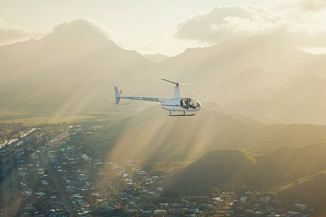
A helicopter ride over Oahu can turn familiar places into a whole new picture, and this 60 Minutes SHARED loop is built for exactly that. I like the huge aerial payoff for the time: you’ll glide over spots like Waikiki and Pearl Harbor without spending hours on roads. I also like that pilots get the balance right—narration that’s informative, but not so heavy that you can’t soak in the views. One thing to consider: it’s weather-dependent, so if conditions aren’t good, your flight can change or be canceled.
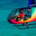
Because this is shared (max 3 travelers), you’re not stuck in a giant pack, and the pilot’s commentary can still feel personal. The itinerary also hits a smart mix: beaches and surf zones, mountain lookouts, and then the solemn WWII landmarks at Pearl Harbor. The drawback is simple: it’s seeing from above—there’s no time on the ground at these stops.
In This Review
- Key highlights at a glance
- How the Honolulu loop really works in 60 minutes
- From HNL over harbors and coastline: what you’ll actually notice
- Diamond Head from the sky: the “how big is it” moment
- Hanauma Bay and Makapuu: seeing the reef lines and tides
- The highway-and-lookout stretch: Punchbowl to Pali
- North Shore energy: Waimea, Haleiwa, and Dole country
- Pearl Harbor from above: the USS Arizona Memorial and ships
- Price and value: is $449 worth a shared helicopter hour?
- Who this fits best on Oahu
- Practical tips to make the flight feel smoother
- Should you book this Honolulu helicopter tour?
- FAQ
- How long is the shared helicopter tour?
- Where do I meet for the tour?
- What’s included with the ticket?
- What is the weight limit per passenger?
- Does the tour depend on weather?
- What’s the cancellation policy for a full refund?
Key highlights at a glance

- Shared small group (max 3 travelers) for a calmer, more flexible feel
- Pilot-led commentary in English, with names like Stefan and Jim showing up in feedback
- Aerial coverage of Waikiki, Diamond Head, Hanauma Bay, Makapuu, and Dole on one flight
- Pearl Harbor from the air, including the USS Arizona Memorial area
- Weather required, so plan for schedule flexibility
How the Honolulu loop really works in 60 minutes
You start and end at 1 Lagoon Dr, Honolulu, HI 96819. The flight is about one hour, and even though that sounds short, it’s the right length for first-timers who want the big wow factor without committing to an all-day plan. You’ll also get a mobile ticket, plus a cell phone lanyard included, which is a nice touch when you’re juggling a camera and directions.
This tour is offered in English, and the company runs it with a clear professional setup. There’s also a 300 lbs total passenger weight limit, so check that early if you’re booking with someone who might be near the upper end.
The big practical thing? This experience requires good weather. You’re trading certainty for views. If conditions are poor, you’ll either be offered a different date or a full refund, so keep that in mind when you’re building your Oahu schedule.
You can also read our reviews of more tours and experiences in Oahu

From HNL over harbors and coastline: what you’ll actually notice

The flight begins at HNL and then sweeps across the south and central parts of Oahu. The route name is long, but the key is what it means in real life: you’ll see how the island’s pieces fit together—harbor, beaches, highways, and the urban grid—at once.
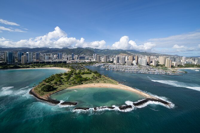
From above, Sand Island and Honolulu Harbor give you a strong sense of how busy the waterfront is. From there, the flight moves toward Ala Moana Beach Park and Magic Island, and this is where the coastline shape becomes obvious. On the ground, these areas can feel like separate stops. From the air, they read like one continuous curve of beach, marina, and city.
Next comes the Waikiki area. You’ll pass Ala Wai Harbor and Waikiki, and the helicopter viewpoint makes it easier to understand why Waikiki is so visually iconic. You can line up the ocean-facing side of the hotels with the inland streets, and it stops feeling abstract.
You’ll also get views of Diamond Head, plus Ala Wai Golf Course and Waialae Golf Course. Even if golf isn’t your thing, these spots help you “read” the island from above—green patches, built-up blocks, and where the land steepens.
Ala Moana to downtown looks quick on a map, but from the air it’s a neat surprise to see how Honolulu Downtown and the shoreline grid overlap. If you like spotting patterns and landmarks, this is the part where your eyes start working like a local.
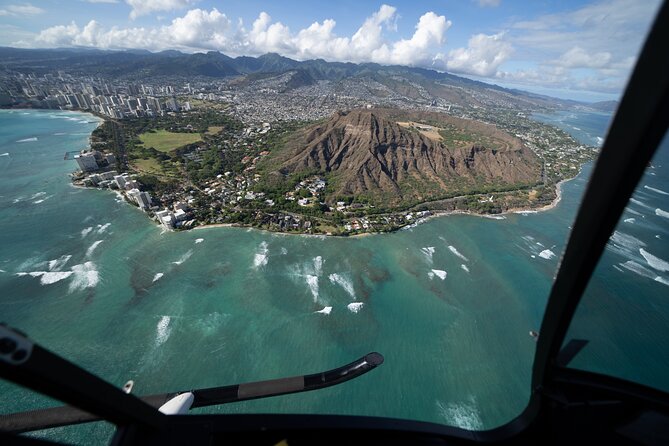
Diamond Head from the sky: the “how big is it” moment

There’s a dedicated Diamond Head stop, and the real value is perspective. From the ground, Diamond Head is a famous shape, but you don’t always grasp how it sits above the ocean and the city grid. From the helicopter, you can see the volcanic slope relative to Waikiki, the coastline bends, and how the rest of the shoreline wraps around it.
This section also helps you connect the city to the island’s older geology. You’ll see the contrast between tightly developed areas and open slopes. It’s one of those moments where your brain clicks: this isn’t just a scenic hike point—it’s a landscape feature that controls views.
Possible drawback: if you’re the type who wants lots of time to look at one spot, the aerial format means you’ll get a great look, then move on. You’re sampling, not parking.
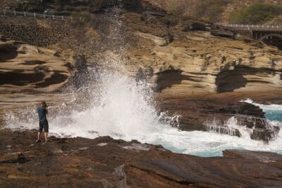
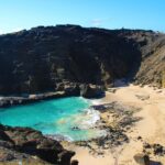
Hanauma Bay and Makapuu: seeing the reef lines and tides

Your flight includes Hanauma Bay Nature Preserve and a stop at Makapu’u Point Tide Pools. From the air, these stops are less about signage and more about pattern recognition—how water color changes, how the bay forms, and where the water looks calmer or more active.
Hanauma Bay from above is especially helpful if you’ve only seen it from viewpoints on land. The curve of the bay becomes clear, and you can better understand why it draws so many people. You also get a sense of distance—how close the preserve sits to the coast and how the surrounding terrain shapes the bay.
Then you shift toward Makapuu Point and the tide pool area. The tide pool stop name is specific, but in practice what you’ll really notice is the coastline geometry: the point extending out, the surf zones on either side, and the way the shoreline changes along the arc. If you like photography, this is often the part where you can get shots that show both ocean and land in one frame.
A consideration here: light matters. You’ll want decent daylight for water texture and reef visibility. If your flight time lands at an awkward angle, the views can still be gorgeous, but the water details may not pop as much.
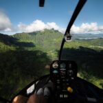
The highway-and-lookout stretch: Punchbowl to Pali
One of the fun things about this itinerary is that it doesn’t treat Oahu like one long beach. It pulls in religion and remembrance areas, then jumps to highway corridors and viewpoint territory.
You’ll see Punch Bowl Cemetery, plus H201 Interchange and the H3 Highway area. Seeing highways from above can be oddly fascinating. It helps you understand how Oahu’s neighborhoods connect without you having to spend your vacation time in traffic. The aerial view makes it clear where movement concentrates and where it opens up.
Then you get Aloha Stadium, Moanalua Gardens, Ala Wai Golf Course again in the overall pass, and the Kaneohe Bay area. If you like variety, this stretch keeps you from getting “ocean blind,” where every shot looks similar.
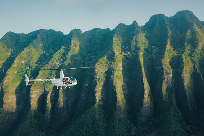
A highlight for scenery lovers is the Pali Lookout segment. Lookouts are famous on the ground because you can see far. From the air, you see why—the terrain drops away, and the island’s interior feels closer than you expected. You’ll also pass named areas like Rabbit Island, OloMana, Gilligan’s Island, and China Man’s Hat. Even if you don’t stop to research them, the aerial perspective turns those names into physical shapes.
There’s also a stop area for famous blow hole, plus Sacred Falls. From the sky, you can’t judge sound or water spray the way you would on foot, but you can often spot the rock formations and the water channels feeding them. It’s a different kind of “wow,” more about form than drama.
You can also read our reviews of more tours and experiences in Oahu

North Shore energy: Waimea, Haleiwa, and Dole country
The itinerary keeps moving toward the island’s north side. You’ll see Jurassic Park, Waimea Bay, and Haleiwa Town as part of the broader Oahu sweep. From above, Waimea Bay is easier to read than it is from a parking lot—surf zones and shoreline breaks become visible, and you can pick out where beach access concentrates.
Haleiwa Town is another “pattern” moment. On the ground it’s a town with shops and streets. From the air it becomes a cluster surrounded by open coastline, and you can see how compact it is compared to the surrounding land.
Then comes Dole Pineapple Plantation. You’ll have a Dole Plantation stop, and you’ll also see the Dole Maze area. Even from the air, the plantation’s layout is distinct. The great part is that it ties your helicopter flight to a recognizable Oahu stop, so it feels like you’re getting both scenic and practical “I was there” landmarks.
One drawback: the itinerary packs a lot of named places into one flight. You’ll see them, but you won’t have time to linger over a single zone. If you’re traveling with someone who likes slow pacing, you may need to temper expectations: this is a highlight reel from above.
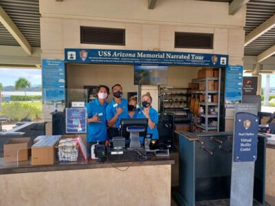
Pearl Harbor from above: the USS Arizona Memorial and ships
If you want one section that makes the helicopter feel more than fun, it’s the USS Arizona Memorial portion and the broader Pearl Harbor pass. You’ll see the Arizona Memorial, along with the USS Missouri, the USS Utah, and mentions of a retired fleet area.
From the air, Pearl Harbor has a strong “layout” feel. You can spot how the memorial sits relative to the water, and you can also see the big shapes of the ships and harbor boundaries. It’s not just a viewpoint—it helps you understand the geography of the whole complex, which is hard to grasp when you’re only seeing one building at ground level.
This is also where the pilot’s tone and pacing matter. In feedback, pilots like Jim are described as informative, and Stefan is mentioned for giving just enough commentary so the passenger still has time to reflect. That balance matters here because you don’t want a loud monologue fighting the moment.
Practical note: this part will feel different from beachy segments. If you’re filming or photographing, keep your expectations realistic. The helicopter is moving, and you’re viewing from a cabin window, so you’ll want to focus on clean framing rather than trying to zoom in on tiny details.
Price and value: is $449 worth a shared helicopter hour?
At $449 per person, this isn’t a budget activity. The question is value per minute, and the answer is mostly yes if you want a high-impact Oahu overview.
Here’s why the price can make sense:
- You get an aerial tour of the island’s major “signature” zones in about one hour
- The group is small (up to 3 travelers), which can feel more personal than mass tours
- You’re seeing both sides of the island story: beaches and lookouts, then Pearl Harbor
It’s also useful that this tour averages 29 days in advance for bookings. That tells me you should not wait until the last week if your schedule is tight. Good weather windows can shift, and helicopter slots don’t always match your ideal time.
Now the realistic downside: this is primarily a view experience, not an on-the-ground tour. If you’re the kind of person who prefers guided stops where you can walk, read, and spend time in museums, you might feel like the time flies too fast. But if you want the “Oahu as a whole” picture, this is one of the fastest ways to get it.
Who this fits best on Oahu
This tour tends to work best for:
- People who want a once-in-a-trip aerial view without doing a full day
- Anyone celebrating a milestone who wants something dramatic and different
- Couples or small groups who like having the sky as their main “guide”
A note on comfort and participation: there’s a 300 lbs total passenger weight limit and a “most people can participate” message in the details. Still, I’d take the weight limit seriously and confirm it before you commit.
Also remember it’s offered in English, so if you prefer full explanation and Q&A style narration, this format can feel easier to follow. If you just want to watch and photograph, the language won’t be a dealbreaker anyway.
Practical tips to make the flight feel smoother
A few practical things help you get the most from this kind of experience.
First, plan around the good-weather requirement. If your Oahu trip has flexible time, pick a day you can adjust. If everything is locked in tight, you might feel the stress when weather decisions happen.
Second, be ready for a longer checklist than you’d expect for a quick trip. Your time on the ground is short, and the flight runs on schedule, so arrive at the meeting point at 1 Lagoon Dr with time to spare. The tour ends right back at that same location.
Third, keep your mindset simple: treat it like a guided aerial loop, not a series of stops you’ll walk around. The airplane-window perspective is part of the charm. If you keep your eyes on horizons, coastlines, and clear landmarks, you’ll get more satisfaction than trying to catch tiny details.
Should you book this Honolulu helicopter tour?
Book it if you want the fastest way to see Oahu as one island map—Waikiki, Diamond Head, Hanauma Bay, Makapuu, Dole, and Pearl Harbor all from the sky. It’s especially appealing if you’re celebrating something or you’re short on days and want maximum wow per hour.
Skip it (or pair it differently) if you’re allergic to weather-based changes or if you prefer time on the ground at specific sites. At $449, you’ll want to feel the “big view return” immediately, not after a delayed payoff.
If you can match your schedule to good weather and you’re comfortable with an aerial, not walking, experience, this is a strong choice for a headline moment on Oahu.
FAQ
How long is the shared helicopter tour?
The flight is about 1 hour.
Where do I meet for the tour?
The meeting point is 1 Lagoon Dr, Honolulu, HI 96819, USA, and the tour ends back at the meeting point.
What’s included with the ticket?
Your ticket includes a cell phone lanyard.
What is the weight limit per passenger?
The total weight per passenger is limited to 300 lbs.
Does the tour depend on weather?
Yes. The experience requires good weather. If it’s canceled due to poor weather, you’ll be offered a different date or a full refund.
What’s the cancellation policy for a full refund?
You can cancel up to 24 hours in advance for a full refund.