REVIEW · HELICOPTER TOURS
Complete Island Oahu Helicopter Tour
Book on Viator →Operated by Blue Hawaiian Helicopters - Oahu · Bookable on Viator
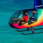
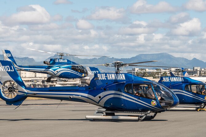
One hour, and Oahu looks different. This small-group helicopter tour (max 6) keeps it personal, and the pilot is also a State of Hawai‘i certified tour guide who talks you through the island in real time. I like that you can hear the details clearly through noise-cancelling headsets and two-way microphones.
Even the big draw is the flight over Pearl Harbor and the USS Arizona Memorial from above. The one catch is that helicopter tours depend on weather, so if visibility or wind is off you may need to reschedule, and late arrivals may not be accepted.
In This Review
- Key reasons this Oahu helicopter tour is worth your time
- The real value: a guided flight, not just a pretty ride
- Pearl Harbor from the air: USS Arizona and the memorial layout
- Honolulu icons: Waikiki hotels, and Diamond Head from Lē’ahi to your seat
- The volcanic-cone snorkeling area: reef shapes you don’t notice from shore
- Lanikai Beach and Kailua: the east side where the water looks unreal
- Kaneohe Bay: sandbar colors and He‘eia Pond’s working-fishing vibe
- The private ranch, the kapu waterfall, and why air-only access matters
- North Shore surf and West Oahu geology: the island’s bigger story in one loop
- Price and what you actually get for $522.50
- Practical tips that make your photos and comfort better
- What to expect on departure day (and how to avoid stress)
- Who this helicopter loop is best for
- Should you book the Complete Island Oahu Helicopter Tour?
- FAQ
- How long is the Complete Island Oahu Helicopter Tour?
- What’s the group size limit?
- What language is the tour offered in?
- Is transportation to and from the heliport included?
- What’s included in the price?
- Are food and drinks included?
- What’s the weight limit and what if I’m over it?
- What should I wear or bring for the flight?
- What’s the check-in time?
Key reasons this Oahu helicopter tour is worth your time
- A max-of-6 aircraft: you get more “pilot attention” than you do on larger tours.
- Pearl Harbor from above: you see the USS Arizona area in a way walking viewpoints can’t.
- Live narration through Bose headsets: you’ll actually understand what you’re seeing while you fly.
- Icon + coastline mix: Honolulu highlights, Lanikai, Kailua, Kaneohe Bay, North Shore surf, and West Oahu all in one loop.
- Optional add-on media: you can buy in-flight photo/video afterward if you want a second set of memories.
The real value: a guided flight, not just a pretty ride
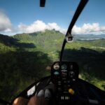
I’ll be honest: lots of helicopter tours sell the same pitch—views, views, views. What makes this one feel more “worth it” is that the pilot is also a State of Hawai‘i certified tour guide. That matters because the flight is only about an hour, and you want context fast.
You’ll wear Bose aviation-grade noise-cancelling headsets plus microphones with two-way communication. The practical upside is simple: if you miss a landmark or want clarification, you can ask. And because the headsets cut the rotor noise, the narration stays understandable instead of turning into background noise.
Group size is capped at 6 travelers, which changes the mood. You’re not crammed shoulder-to-shoulder with strangers. If you’re the type who likes to pay attention (or just wants a calmer ride), this is a big deal.
You can also read our reviews of more tours and experiences in Oahu
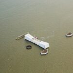
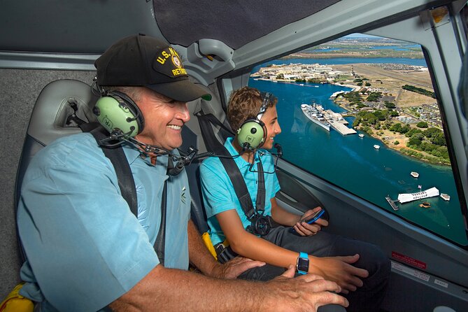
Pearl Harbor from the air: USS Arizona and the memorial layout
The tour’s most solemn stop is built into the loop: the USS Arizona Memorial at Pearl Harbor. It’s the resting place of 1,102 of the 1,177 sailors and Marines killed on USS Arizona during the December 7, 1941 attack.
What you get here is less about “learning a fact” and more about seeing the scale. From ground level, the memorial anchors the story. From the air, you grasp how the surrounding shoreline and harbor shape the experience. It helps you understand the geography of where events unfolded.
The flight also ties in the larger Pearl Harbor National Memorial at Joint Base Pearl Harbor-Hickman, which includes nine historic sites that represent different angles of the Pacific war story. Even if you don’t stop on foot at each site, the aerial view gives you a quick mental map—then you can connect it to what you’ll read or revisit later.
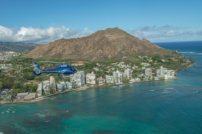
Honolulu icons: Waikiki hotels, and Diamond Head from Lē’ahi to your seat
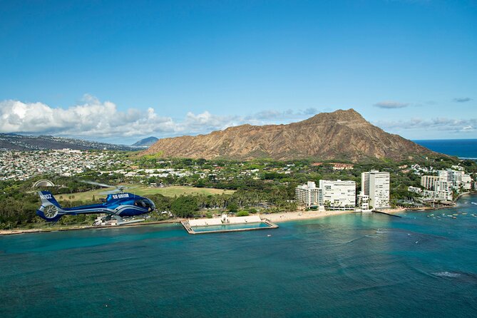
After Pearl Harbor, the route slides toward the Honolulu coast. The shoreline near Waikiki comes into view with high-rise hotels lined along the water. That aerial perspective makes Waikiki’s shape obvious: it’s a coastal corridor with dense development right up against the surf line.
Then comes Diamond Head (Lē’ahi), Hawaii’s iconic volcanic cone. From above, you don’t just see a mountain—you see its edges and the way it sits at the edge of Honolulu. It’s the kind of view that instantly tells you why postcards worked in the first place, but also why this moment feels different: you’re reading the landforms directly, not through a viewpoint gap.
If you’re photo-focused, this is a good stretch to get your phone ready early—more on that in practical tips.
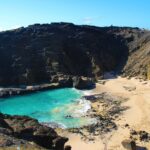
The volcanic-cone snorkeling area: reef shapes you don’t notice from shore
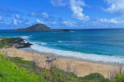
One of the stops is a marine preserve formed within a volcanic cone. It’s known for strong protection of marine life and has reef formations that create distinctive “constellations” of structure underwater. That’s why it’s regularly treated as one of Oahu’s premier snorkeling spots.
Flying over it doesn’t replace snorkeling, but it does something snorkeling can’t: it shows how the bay formation protects the water and how that structure creates the conditions marine life relies on. You also get the thrill of spotting patterns you’d normally miss when you’re only focused on what’s right in front of your mask.
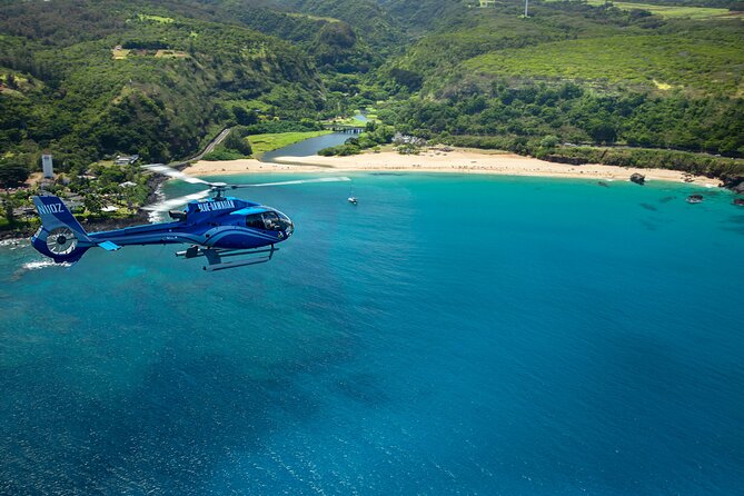
Lanikai Beach and Kailua: the east side where the water looks unreal
The next stretch is all about the east side’s reputation for clear water and white sand. Lanikai Beach is consistently described as the Best Beach in America, and in the air you’ll see why: the coastline reads as clean lines with calm-looking water close to shore.
Then you fly over Kailua, the main town on the windward (east) side. Expect the gentle-wave feel from above, plus the layout of beaches and shoreline areas. Nearby are the Mokuleia Islands, about a mile offshore, which provide sanctuary to Native birds—another reminder that the east side isn’t only beaches. There are “live geography” pieces to spot too.
If you’re planning a beach day during your trip, this portion is where you can decide which sand you actually want to walk on—because the aerial view makes the differences easier to judge.


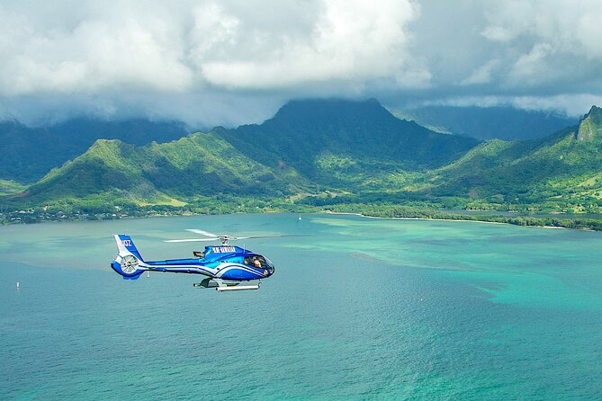
Kaneohe Bay: sandbar colors and He‘eia Pond’s working-fishing vibe
Kāneʻohe Bay is the tour’s big sheltered-water moment. It’s described as the largest sheltered body of water in the islands, and it’s also tied to recreation.
From the air, the bay’s signature feature is the sandbar colors—shades you can’t fully appreciate from the shoreline because you don’t see the full shape of where the sand meets the water. It’s one of those “wow, that’s exactly what I hoped it would look like” visuals.
The route also includes He‘eia Pond along the shore, where ancient Hawaiian fishing traditions remain alive. What I like about including this is that it keeps the flight from being only about beach aesthetics. You get a sense of continuity: this is a working coastal tradition, not a staged landscape.
The private ranch, the kapu waterfall, and why air-only access matters
The tour continues over a private nature reserve and working cattle ranch. It’s popular with visitors and also used for movie filming locations, which gives you an interesting angle: land that’s actively used, not just preserved as a backdrop.
Then you get the “you can only really see this from the air” moment: a dramatic 1,100-foot waterfall described as kapu, forbidden. The key point for your expectations is right in that detail. The surrounding landscape is only accessible by air, so what you’re buying is a view you literally can’t reproduce from the road or typical viewpoints.
If you’re asking whether helicopter tours are worth it beyond the novelty, this is where you’ll feel the answer. Some places are blocked by rules or terrain; the aircraft turns that limitation into part of the experience.
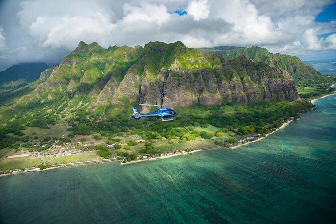
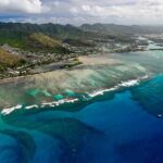
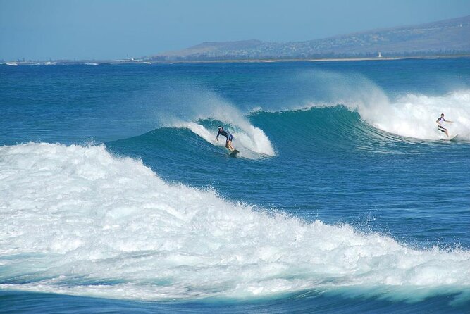
North Shore surf and West Oahu geology: the island’s bigger story in one loop
Oahu’s North Shore shows up with its world-famous surf. The tour specifically references the “7-mile miracle,” linked to expansive reef formations along the coast that create surf conditions.
From the air, you can see the reef pattern and the way the coastline bends—so the surf story starts to make sense. You’re not just hearing about surf breaks; you’re watching the coastline’s shape that helps generate them.
The route then turns toward West Oahu, where you see the eroded remains of an ancient shield volcano that forms the western half of the island. That’s a geography-heavy moment, but it’s also one of the most educational in a non-lecture way. Helicopter altitude gives you a broad view of how volcanic history shapes where settlements and coastlines developed.
Later you fly along the Nanakuli Forest Reserve, spanning mauka to makai (mountain to sea), down to its namesake beach park, noted as a favorite playground for locals of West Oahu. That’s a powerful contrast: you get “Oahu the tourist map” and “Oahu the daily-life coast” in the same hour.
Finally, the leeward coast includes a master-planned vacation and residential community nicknamed The Place of Joy. You’ll see how modern Oahu’s development sits against the island’s edge—again, not just pretty, but informative.
Price and what you actually get for $522.50
At $522.50 per person, this isn’t a “cheap add-on.” So the question isn’t just whether it’s expensive. It’s whether it’s efficient.
For an hour and five minutes (approx.), you’re covering a lot of Oahu’s most recognizable areas: Pearl Harbor, Honolulu landmarks, east coast beaches, Kaneohe Bay, North Shore surf, and geologic West Oahu features. Add in the included state-certified pilot-guide narration, Bose headsets, and two-way communication, and the cost starts to look like you’re paying for time compression plus explanation.
This tour is also built around a small aircraft: max 6 travelers, with serious weight planning. If you compare that to big-bus group tours that still leave you doing lots of driving, you can see why people consider this “worth it.” You’re not buying comfort alone; you’re buying access to views and locations you can’t easily replicate quickly on land.
Practical tips that make your photos and comfort better
A few rules here really do affect your experience:
- Wear dark colored clothing so you don’t reflect in photos.
- Skip hats, bags, large cameras, and extending selfie sticks. If you’re bringing camera gear, keep it simple.
- Bring a credit card in case you want optional in-flight video/photo packages and souvenirs after the flight.
- If you plan to rely on your phone for photos, charge fully beforehand. Some pilots have advised bringing a fully charged phone battery so you can keep shooting.
Seat tip: if you have a choice, the front seat is often the best for views and photo angles. The earlier the plane ride begins, the earlier you get that clear, less-angled perspective.
Weight note: the total weight per passenger is capped at 240 lbs. If you’re over that, an adjacent empty seat is required to balance the aircraft, with the second seat charge at half off. Arrange that extra seat after booking so the flight stays compliant.
What to expect on departure day (and how to avoid stress)
Check in is 45 minutes prior to your tour time. This is for weight check-in, safety briefing, and getting you seated on time. Late arrivals may not be accepted and are non-refundable, so build extra buffer if you’re driving or using public transportation nearby.
Also plan around two physical limits:
- No scuba diving within 24 hours of departure.
- If weather is poor, the tour may be canceled and you’ll be offered another date or a full refund.
One more small-but-important comfort point: you’re in the air, so listen for the pilot instructions. With two-way microphones and narration, paying attention early makes the whole flight feel like a guided tour instead of just aerial sightseeing.
Who this helicopter loop is best for
This tour is a strong fit if you:
- Want the fastest way to see both sides of Oahu (Honolulu + east coast + North Shore + West Oahu).
- Like structured guidance, not guessing from landmarks.
- Prefer a quieter group experience with maximum 6 travelers.
- Want a serious “wow” moment that includes Pearl Harbor and an air-only view like the kapu waterfall area.
It’s also a good choice for couples or small groups who can coordinate schedules. If you’re traveling with kids, the info sheet notes that children 23 months and younger are complimentary as lap children—so you’ll want to consider whether that’s workable for your situation.
If you hate any chance of rescheduling due to weather, keep in mind helicopters are at the mercy of wind and visibility.
Should you book the Complete Island Oahu Helicopter Tour?
Book it if you want one guided hour that covers a lot of Oahu you’d never “finish” in the same day by car, and if the idea of flying over Pearl Harbor and seeing the island’s geology and coastlines from above feels like your kind of souvenir.
Skip it if your travel style is mostly slow and land-based, or if $522.50 per person feels like too much for a single flight where weather can shift plans. In that case, you might do a mix of driving stops and one more targeted experience on the ground.
If you do book, charge your phone, wear dark clothes, and show up early. This is the kind of tour where preparation makes the hour feel twice as smooth.
FAQ
How long is the Complete Island Oahu Helicopter Tour?
The flight duration is about 1 hour 5 minutes (approx.).
What’s the group size limit?
This is a small-group tour with a maximum of 6 travelers.
What language is the tour offered in?
The tour is offered in English.
Is transportation to and from the heliport included?
No. Transportation to and from the heliport is not included.
What’s included in the price?
Included items are the pilot guide (also State of Hawai‘i certified tour guide), Bose aviation-grade electronic noise-cancelling headsets, microphones with two-way communication with the pilot, and all fees and taxes.
Are food and drinks included?
No. Food and drinks are not included.
What’s the weight limit and what if I’m over it?
The total weight per passenger is 240 lbs. For each guest weighing over 240 pounds, an adjacent empty seat is required; the second seat charge is half off of the regular tour price, arranged after booking.
What should I wear or bring for the flight?
Wear dark colored clothing so it doesn’t reflect in photos. Hats, bags, large cameras, and extending selfie sticks aren’t permitted. Bring a credit card for optional video/photo packages and souvenirs at the heliport.
What’s the check-in time?
Check in is 45 minutes prior to tour time. Late arrivals may not be accepted and are non-refundable. Tours/times can vary due to wind and weather.