REVIEW · HELICOPTER TOURS
30 Minutes SHARED Helicopter Tour in Honolulu
Book on Viator →Operated by Honolulu Helicopter Tours · Bookable on Viator
Honolulu from the sky feels like a cheat code. This 30-minute shared helicopter tour gives you views of Oahu that don’t exist from the ground, and you get the pilot’s live commentary while you’re up there. I especially like the max-three-guest setup (it keeps things personal) and the big photo moments as the route threads through Waikiki and beyond. The main downside: at $319 per person, it’s not cheap for just half an hour of flying.
What makes this one work is the way it’s built around the Honolulu area—harbor to beaches to icons—so even with limited time, you still get a full “Honolulu picture.” The flight is also designed to be easy to enjoy: you’ll have aviation headsets for clearer pilot talk, plus a cell phone lanyard to help keep your camera gear under control.
If you’re sensitive to weather swings, plan to be flexible. This experience needs good weather, and if conditions aren’t right, your flight can be rescheduled or refunded.
In This Review
- Key things that make this helicopter tour worth it
- Getting started at 1 Lagoon Dr, Honolulu
- Why 30 minutes can feel like more than it sounds
- The route: HNL, Sand Island, and Honolulu Harbor from above
- Sand Island
- Honolulu Harbor (Port of Honolulu)
- Ala Moana Beach Park and Magic Island: coastline you can actually recognize
- Ala Moana Beach Park
- Magic Island
- Ala Wai Harbor to Waikiki: harbors, hotels, and Diamond Head lining up
- Waikiki and the coastline
- Diamond Head (Lēʻahi)
- Waialae Country Club and Honolulu’s “in-between” neighborhoods
- Downtown Honolulu and Aloha Tower: skyscrapers plus royal and museum sites
- A respectful photo approach near memorials
- Punchbowl Crater and the National Memorial Cemetery of the Pacific
- Moanalua Gardens, Hitachi tree, and the “green spaces” you can’t reach fast
- Interchange and H-3: tunnels, bridges, and the engineering view
- H201 interchange
- Moanalua Freeway and Route 78 designation
- Interstate H-3 (John A. Burns Freeway)
- Black Point sea pools and Aloha Stadium
- Value check: $319 for 30 minutes and why it can still be worth it
- Weather reality: when the flight can change
- Should you book this Honolulu shared helicopter tour?
- FAQ
- How long is the helicopter tour?
- What does the tour cost per person?
- How many people are on this shared helicopter tour?
- What’s included with the admission?
- Is the tour offered in English?
- Where do we meet for the tour?
- Is there a weight limit?
- What happens if the weather is poor?
- What’s the cancellation window for a full refund?
Key things that make this helicopter tour worth it
- Small group (max three travelers) for a quieter, more focused ride
- Pilot commentary that explains what you’re seeing as you pass it
- A tight 30-minute route packed with Honolulu icons and coastlines
- Photo-friendly aerial angles over Waikiki, Diamond Head, and the harbors
- Aviation headset + cell phone lanyard included so you can enjoy the moment without fuss
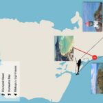
Getting started at 1 Lagoon Dr, Honolulu
Your trip starts and ends at 1 Lagoon Dr, Honolulu, HI 96819. It’s the kind of meeting spot that’s straightforward: you’ll find it without turning your vacation into a scavenger hunt, and the area is described as near public transportation. You’ll also use a mobile ticket, so have your confirmation ready on your phone.
Once you’re checked in, the experience shifts fast from paperwork mode to flight mode. That short on-the-ground time matters here, because the whole value is in the air time.
You can also read our reviews of more tours and experiences in Oahu

Why 30 minutes can feel like more than it sounds

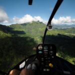
Thirty minutes goes quickly when you’re watching beaches and neighborhoods slide by at speed, but that’s also the point. This isn’t a long, slow tour where you wait around for the next view. It’s a concentrated loop across the Honolulu region, so you keep getting new angles without losing the sense of momentum.
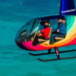
I also like the feel of the small group. With no more than three travelers, you’re not sharing the ride with a busload of people. That matters for two reasons: you hear the pilot better, and you get fewer distractions around you when it’s time to look.
And yes, some flights are done with the doors off (one of the strongest recommendations in the feedback). Doors-off flying usually means more airflow and more dramatic photo views, but if you’re the type who wants the calmest experience possible, just be aware that door setup can change the feel of the ride.
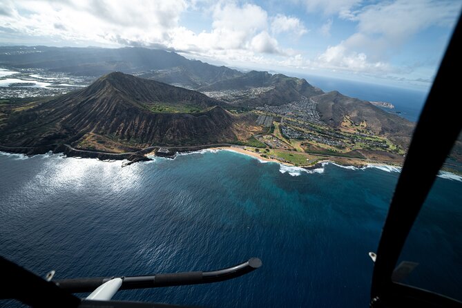
The route: HNL, Sand Island, and Honolulu Harbor from above
The flight starts and ends back at HNL, then the route works its way across key parts of Honolulu. The first big “wow” zone is the harbor area.
Sand Island
Seeing Sand Island from above helps you understand how Honolulu’s shoreline is engineered—where land, reef, and port infrastructure meet. From street level, you mostly experience the city by what’s in front of you. From the air, you see the city’s shape and how everything lines up.
Honolulu Harbor (Port of Honolulu)
Next you’ll get a clear view of Honolulu Harbor, also known with names like Kulolia and Ke Awa O Kou. From the air, it’s easier to grasp this as the island’s main maritime hub, with ships and docks arranged along a working waterfront.
Practical tip: if you care about photos, keep your camera ready during the harbor stretch. A lot of the best “pattern shots”—piers, coastline curves, and water color changes—happen fast.


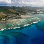
Ala Moana Beach Park and Magic Island: coastline you can actually recognize
After the harbor, the tour moves along the Ala Moana area.
Ala Moana Beach Park
Ala Moana Beach Park is described as a free public park with a 100-acre footprint and a beach that runs over half a mile. From above, you’ll be able to match the long stretch of sand to the area you’ve likely walked (or looked at) from Waikiki.
The drawback of touring by air: you don’t feel the breeze the same way you would on the sand. But you do get a better understanding of how the shoreline sits relative to the city.
Magic Island
Right next to Ala Moana, you’ll pass over Magic Island, a small man-made peninsula. It was created in 1964 for a resort complex, and later converted to a park. The name was changed to Aina Moana, though that newer name doesn’t show up often.
This is the kind of stop where the air view adds meaning. From ground level, the peninsula can feel like just another stretch of coast. From above, you see it as an intentional piece of the waterfront plan.
Ala Wai Harbor to Waikiki: harbors, hotels, and Diamond Head lining up
Then the route brings you over Ala Wai Harbor, described as the largest small boat and yacht harbor in Hawaii. It sits between Waikiki and downtown Honolulu, and from above you can clearly see how the waterway channels shape movement toward the ocean.
Waikiki and the coastline
From the air, Waikiki’s coastline layout becomes much easier to read. The tour description calls out high-rise hotels along the shore and the general spread of activity from surf beaches to the commercial streets near Kalakaua Avenue. You might also spot the way Waikiki bends around the bay, with Diamond Head hanging off to one side.
This is one of the best stretches for quick comparisons. If you’ve been on the beach for a day or two, you’ll recognize the neighborhood geometry fast when you see it from above.
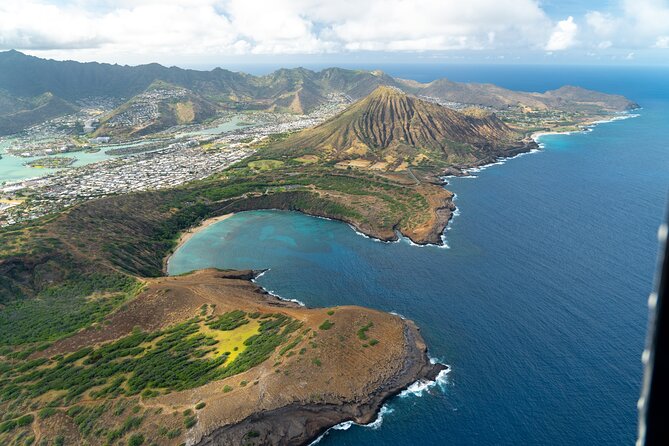
Diamond Head (Lēʻahi)
Then comes Diamond Head, a volcanic tuff cone also known as Lēʻahi. You’ll see the ridgeline shape that Hawaiians link to the idea of a tuna’s dorsal fin.
Diamond Head is also one of those places where an overhead view helps even if you’ve never visited. It’s not just a hill—it’s a landmark with a strong silhouette. Seeing it from the helicopter makes it feel like a true island icon rather than a distant backdrop.
Waialae Country Club and Honolulu’s “in-between” neighborhoods
The itinerary includes a pass over Waialae Golf Course / Waialae Country Club. It’s a private club, and it’s framed as a championship course. From above, you’re not there to golf—but you can still appreciate the grid of fairways and the way golf course land parcels sit inside the broader Honolulu built environment.
This segment is a nice reminder that the flight isn’t only about the postcard hotspots. You also get glimpses of “real Honolulu” geography—places that shape daily life, even if you won’t spend your vacation time there.
Downtown Honolulu and Aloha Tower: skyscrapers plus royal and museum sites
Next on the route is Honolulu downtown, including key highlights you’d recognize from ground level.
The tour area description notes skyscrapers and Iolani Palace, a restored 19th-century royal residence with original furnishings. It also calls out the Hawaii State Art Museum for contemporary local art, plus the Aloha Tower Marketplace on the waterfront with sea views.
From above, downtown is all about lines: streets, blocks, and the way the waterfront sits below it all. The helicopter view makes you see how tightly the city is packed around the coast.
A respectful photo approach near memorials
This part of the route also sets up the emotional shift toward Punchbowl.
Punchbowl Crater and the National Memorial Cemetery of the Pacific
The flight includes Punchbowl Crater, home to the National Memorial Cemetery of the Pacific. It’s described as a national cemetery honoring U.S. Armed Forces service members and those who gave their lives.
From the helicopter, you’re viewing it quickly, but the aerial perspective can still help you understand the crater’s shape and how the memorial complex sits within the terrain. Keep your tone and attention respectful here. If you’re taking photos, aim for quick, steady shots rather than crowding the moment.
Moanalua Gardens, Hitachi tree, and the “green spaces” you can’t reach fast
Then you’ll head toward the Moanalua Gardens area. The tour description frames it as a 24-acre privately owned public park with the Kamehameha V Cottage, once home to Prince Lot Kapuāiwa (later King Kamehameha V). It also mentions the annual Prince Lot Hula Festival and a large monkeypod tree known in Japan as the Hitachi tree.
From above, parks like this show you how Honolulu balances development with preserved land parcels. You also get a sense of where these areas sit relative to major roads and freeways, which helps if you’re trying to understand traffic patterns from your hotel base.
Interchange and H-3: tunnels, bridges, and the engineering view
This tour leans into the highway story too, and that’s a big part of its appeal for some people.
H201 interchange
You’ll fly over the H201 Interchange (not described in detail here, but it’s one of the named route points). Aerial views are great for understanding how multiple routes connect across Honolulu’s varied terrain.
Moanalua Freeway and Route 78 designation
The description notes that a section of the Moanalua Freeway between Route 99 (Kamehameha Highway) and the western H-1 interchange remains designated as Route 78. Even if you don’t care about highway numbers, these points help you see the “plumbing” of the island.
Interstate H-3 (John A. Burns Freeway)
Next: Interstate H-3, also called John A. Burns Freeway. The route description says it crosses the Ko‘olau Range along viaducts and through the Tetsuo Harano Tunnels—with a length of 5,165 feet—plus smaller Hospital Rock Tunnels.
This is a “non-beach” highlight that still feels scenic. When you look at the aerial engineering, it gives you a new appreciation for why Honolulu feels both tropical and intensely built at the same time.
Black Point sea pools and Aloha Stadium
The flight includes Black Point Sea Pools. From above, coastal rock formations and sea-pool areas are easier to grasp as a system—water edges, rock shapes, and where the coastline breaks.
Finally, the route includes Aloha Stadium in Halawa. The description says it’s the largest stadium in Hawaii and that fan-attended operations ceased indefinitely as of December 2020, with a moratorium on scheduling new events. That means you might see a stadium complex that looks more quiet from the air than you expected.
This end segment is a good reminder: even if a landmark feels familiar by name, aerial views can still surprise you with how it sits in the surrounding neighborhood grid.
Value check: $319 for 30 minutes and why it can still be worth it
At $319 per person for about 30 minutes, you’re paying for a specific kind of convenience: maximum sightlines in minimum time. This isn’t the cheapest way to see Honolulu. It is, however, one of the fastest ways to connect all the major zones—harbor, beaches, downtown, memorial areas, and the highway corridor that cuts through the island.
The best “value” here is the small group. When you’re maxed at three travelers, you’re less likely to feel crowded, and the pilot’s information tends to land better. Add aviation headsets and you’re not stuck guessing what the pilot is saying while you’re trying to enjoy the ride.
Also, the inclusion of a cell phone lanyard is practical. Helicopter flying can make you fumble with gear. Anything that helps you keep your phone secure and ready matters when the best views pass fast.
Weather reality: when the flight can change
This tour requires good weather. If the experience gets canceled due to poor weather, you’ll be offered a different date or a full refund. That’s important to know because the route is short and time-sensitive: you’re buying a window in the forecast.
If your Oahu schedule is tight, consider booking earlier in your stay so you have a backup day if weather changes.
Should you book this Honolulu shared helicopter tour?
I think you should book it if you want a high-impact way to see Honolulu in a short time, and you like the idea of a max-three flight with pilot commentary. It’s also a strong fit for first-timers who want the major landmarks in one go—Waikiki, Diamond Head, Honolulu Harbor, downtown, and the memorial at Punchbowl.
I’d skip it if your priority is long, leisurely sightseeing or if you know you’ll be unhappy sacrificing part of your day to weather uncertainty. And if $319 feels heavy, treat it as a splurge—because it is.
One more useful angle: if you care about photos, ask the crew how the door setup works for your particular flight. Some people specifically recommended flying with doors off, and that kind of option can dramatically change what your camera can capture.
FAQ
How long is the helicopter tour?
It’s about 30 minutes.
What does the tour cost per person?
The price is $319.00 per person.
How many people are on this shared helicopter tour?
The experience has a maximum of 3 travelers.
What’s included with the admission?
Admission includes aviation headset and a cell phone lanyard.
Is the tour offered in English?
Yes, it’s offered in English.
Where do we meet for the tour?
The meeting point is 1 Lagoon Dr, Honolulu, HI 96819, USA.
Is there a weight limit?
Yes. Total weight per passenger must be 300 lbs.
What happens if the weather is poor?
The tour requires good weather. If it’s canceled due to poor weather, you’ll be offered a different date or a full refund.
What’s the cancellation window for a full refund?
You can cancel for a full refund if you cancel up to 24 hours in advance. If you cancel less than 24 hours before the start time, the payment is not refunded.